


1840-1844, When Wedowee was McDonald
In 2019 Alabama will celebrate 200 years as a state. I grew up in Wedowee, the county seat of Randolph County, and have fond memories of that little town of 500 during the late ’50s.
In the 1980s, I was perusing old maps in a map shop in Lahaina, Hawaii, when I found an antique map of Alabama published by Thomas Cowper Waite, circa mid-1800. This was a map showing the roads and distances of stage and steamboat routes. I quickly noticed that in Randolph County in the area where Wedowee should be located was the name “McDonald.” I purchased the map, had it framed and it hangs on the wall of my TV and train room upstairs.
Some time later, I consulted with my uncle, Jimmy New of Wedowee, regarding this and as I thought, he had a good explanation. He has done extensive genealogical research on both the New and McDonald families. His mother, my grandmother, was a McDonald and a direct descendant of James Samuel McDonald Jr. for whom the town was renamed, even though for only four years.
Our ancestor, James Samuel McDonald Sr. was born in the Carolinas in 1776 and finally migrated to Randolph County in the late teens to early 1820s. He had been a successful farmer, businessman and politician. Several other McDonald families moved into the area during this time, coming immediately after the Creek Cessation of land and statehood, which occurred in 1819.
A look back at how Wedowee came to be and how the state was formed is in order here.
In 1783, the area of Alabama and Mississippi was a part of the Southwest Territories; imagine that East Alabama was considered part of the Southwest! During the late 1790s to early 1800, all of this land was claimed by Georgia as their territory. Finally with federal pressure, Georgia ceded this land and it became the Mississippi Territory. The main settlements then were on the Mississippi River at Natchez and other river settlements with a small population in the Mobile area. As a result, Mississippi applied and was granted statehood in 1817. Interestingly however is that this came during the Creek Cessation of land, and settlers literally poured into east and north Alabama to the point that quickly the population of the Alabama Territory was greater than that of the State of Mississippi. Many of these settlers were of Scotch-Irish descent.
Quickly after 1817, Alabama met the requirements for statehood and was granted statehood in 1819.
Randolph County was established Dec. 18, 1832, and was carved out of the last Creek Cessation of land. John Randolph of Petersburg, Va., a Congressman and former minister to Russia, was the county’s namesake.
Randolph County initially had an area of 600 square miles, but was decreased significantly by forming a portion of the northern section to form Cleburne County and part of the western portion to form Clay County. So, Mother Randolph helped give birth to these neighboring counties.
The Wedowee area was of course inhabited since about 4,000 BC by Native Americans and most recently by the Muscogee Creeks. The settlement in the early territorial years was a trading post by the name McDonough, which sounds very Scottish. I have so far been unable to find any history as to who actually began the trading post. I do know that Roanoke was High Pine, Woodland was Lamar, and Wadley was near Louina. An interesting point is that Louina was a prosperous Creek lady who had land and a trading post on the west bank of the big Tallapoosa about 10 miles west of Wedowee. The name, Wedowee, came from and Indian chief, Wina’Towa, which in Muscogee Creek means “rolling water” or “old water.”
The first county seat and court was held near her lands at Triplett’s Ferry. In 1835 the county seat was moved to the present site of Wedowee, the reason for the move was a state stature requiring the county seat to be near the geographic center of the county. Wedowee is near the center of the county. I want to add that the first county court session was held under a large oak tree at Triplett’s Ferry with judge, lawyers, etc. in attendance. The case was about a land dispute, which was a common topic of dispute in those early days. For you history buffs, look up the great land fraud case that occurred in those early days, the Yazoo Land Fraud.
So, how did Wedowee get a name change to McDonald? It seems that in 1839, a young state representative, Francis Perryman, did it probably as a political favor to his friend and our ancestor, James Samuel McDonald Jr., who was a young county commissioner at that time. Somewhere in my reading, I gather he had the names of several other settlements changed. This seemed to gain him the ire of a goodly number of residents. I wonder if he was re-elected? There was immediate controversy and after four years, the U.S. Congress changed the name back to Wedowee in 1943-44.
I have been told there is no other town known to have the name Wedowee.
The map printed in Philadelphia in 1850 still had the area listed as McDonald, which may indicate that information then did not travel at internet speed.
In summary, I wonder if Mr. Perryman, instead of changing the name as a political favor, possibly made the change to more closely relate the Scottish name, McDonough (the original trading post). I leave that to conjecture, however, it sounds better to those of us who have McDonald DNA to believe he named the town after our ancestor, James Samuel McDonald Jr.
James S. McDonald Jr.’s gravesite is almost on the highway 48 right of way near Graham with the following inscription on his headstone:
Hark ye strangers
As you pass me by
As you are now,
Once was I.
As I am now,
You soon will be.
Take up the cross
And follow me.
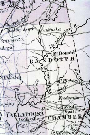
A rare mid-1800s map shows McDonald rather than Wedowee.

